Posts

Showing posts from May, 2015

Quandaries along a journey on wildlife conservation
Image
Share a piece published on DTE blog during May 2015. We are a people in a quandary about the present. We are a people in search of our future. -Barbara Jordan I have experienced more than a few dilemmas in the course of my journey in wildlife conservation. But I believe that conversations with people, some of whom I learn from in no small measure, have helped to enrich the journey and also underscore these quandaries. Any of these quandaries that you will read about hereon emerge by virtue of practices widely accepted today. However, complex challenges that confront wildlife conservation presently warrant a relook at the conventional practices . A programme-director at a conservation organisation recently shared his experiences. He told that whenever he asks his colleagues about the next step in conservation, after camera-trapping or the use of automated cameras to capture wildlife, he, unfortunately, gets only one answer from them. In a very confident tone, they always s

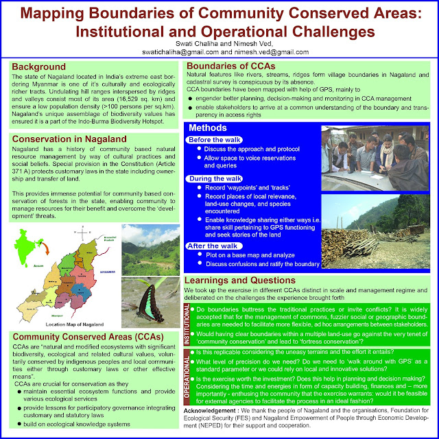
Mapping boundaries of Community Conserved Areas: Institutional and operational challenges

Image
Pleased to share a poster presented at IUFRO 2014 World Congress Congress Theme:  Forests for People Title:  Mapping boundaries of Community Conserved Areas: Institutional and operational challenges Authors:  Swati Chaliha and Nimesh Ved Abstract: Defining spatial boundaries of Community Conserved Areas (CCA) are perceived as pertinent for stakeholders to have common understanding and for laying down operational rules. In Nagaland, India assigning natural features as boundaries have been a customary practice and cadastral maps do not exist. Having CCA boundaries here is crucial in the wake of current development and conservation paradigm. Process of mapping boundary led to myriad questions. While in one CCA of Nagaland, authors with villager’s support mapped boundary by walking with GPS receivers, and data analysed using GIS; in another CCA efforts involved equipping selected villagers with skills of using GPS for mapping. In the first case, an organized arrang